Why Rivers Meander Across Nearly Flat Ground
Why rivers meander across nearly flat ground comes down to gravity, erosion, and deposition. Learn to read bends and floodplain traces without mistaking clues for proof.
The common mistake is to treat a nearly flat river as a straight channel that has lost its direction. That makes bends look decorative and old channel traces look more certain than they are. Why rivers meander across nearly flat ground comes down to a slight downhill gradient and the way moving water shifts sediment from one bank to another.
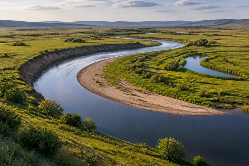
Even a gentle slope carries water across a lowland. In bends, the strongest current tends to press toward the outer bank, where it can remove sediment. Slower water along the inside of the bend allows some sediment to settle. The resulting erosion and deposition move the channel sideways over time.
What keeps water moving across a flat-looking plain?
“Flat” usually means the slope is too gentle to notice at a glance, not that the land is level. Over a long distance, the river still descends. Gravity supplies the energy; the channel and its banks influence where that energy is spent.
Flow is not equally fast everywhere. Water near the bed and banks meets friction, while water farther from those surfaces can move more freely. In a bend, the main current tends to swing toward the outside of the curve, pressing against the outer bank and carrying away loose sediment.
Water also circulates across the channel. Faster flow near the outside is associated with a slower return flow near the bed toward the inside. This helps move sediment around the bend. The pattern varies with channel shape, water level, and bank material, but the broad result is familiar: outer-bank erosion and inner-bank deposition.
Why does one bank erode while the other builds?
At the outside of a bend, moving water can undercut the bank, especially where it contains loose sand, silt, or gravel. Pieces may slump into the channel after support below them is removed. The river can carry some of that material downstream or around the bend.
On the inside, slower water has less ability to keep sediment in motion. Sand and finer particles can settle, forming a gently sloping deposit called a point bar. Material removed from one place may be laid down elsewhere, though not necessarily in the same amount or at the same time.
Vegetation affects both sides. Roots may help hold bank material together, while plants on a point bar can trap sediment and stabilize the deposit. Neither effect freezes a bend in place. Channel shape, sediment supply, and changing flow conditions all matter.
How does a bend migrate instead of simply getting wider?
As erosion eats into the outer bank and deposition adds to the inner bank, the bend can shift across the floodplain. This sideways movement is called lateral migration. The channel may also lengthen as its curves become more pronounced, even though the valley’s overall route remains broadly downstream.
A river bend is a little like a loose hinge on a swinging gate: its position changes while the general direction of travel stays the same. The comparison has limits. A river is not rigid, and its banks may respond unevenly.
Say you are looking at an invented river bend on a grassy floodplain. The outer bank is loose silt, and a shallow sandy bar lies on the inner bank. You compare two map images from different dates, using the same bend and nearby road junction as fixed reference points. First, you trace the water’s edge on each image; then you note whether the outer bank has shifted into the floodplain and whether the inner bar has extended into the channel. If both changes appear in the same direction, the expected visible pattern is sideways migration, not a sudden leap to a new route. If the images use different scales or seasons, the comparison is inconclusive, so you would avoid assigning a direction from them alone.
How can you read former river routes on a floodplain?
Floodplains are low areas beside rivers where water and sediment can spread during floods. A migrating channel may leave curved ridges, shallow depressions, or crescent-shaped ponds where a former channel was cut off from the main flow. These features are clues, not a complete record: vegetation, drainage, and later sediment can obscure their shape.
To inspect a floodplain from a safe public viewpoint, compare the active river with the low ground on a map or aerial image. Use visible roads, field edges, and the present channel as reference points. Look for arcs roughly parallel to the active channel, but treat each as a possible former route rather than certain evidence.
- If an arc follows the river’s curve and sits in a shallow depression, mark it as a possible abandoned channel; if it does not match the channel’s shape, consider drainage or another landform instead.
- If a crescent-shaped pond lies beside a bend, compare its orientation with the river; if the curve aligns, treat cutoff as a plausible explanation, but if it does not, leave the origin open.
- If a curved ridge borders a lower area, check whether the ridge tracks the river’s bend; if it does, consider a former bank or bar, but if it crosses the floodplain without matching the channel, do not assign it that role.
- If the feature appears in more than one map or aerial image, check that the images show the same ground and comparable detail; if they do, use the repeated shape as a stronger clue, but if they differ in scale or coverage, keep the identification tentative.
- If vegetation hides the ground pattern, compare a topographic map with an aerial image; if both show the same arc, retain it as a candidate former route, but if they conflict, record the uncertainty rather than choosing the clearer-looking image.
- If a feature lies near the active channel, check whether it is separated from the water by a continuous strip of land; if so, it may be an abandoned route, but if open water connects it to the river, consider whether it is still part of the active channel system.
Meanders also distribute sediment in different ways. Coarser particles often settle where flow loses energy, while finer material may travel farther across a floodplain. That sorting helps explain why land beside a river can vary over short distances, even where the terrain looks uniformly flat.
What questions help distinguish a meander from other channel patterns?
Does a meandering river move faster than a straight river?
Not as a simple rule. Speed varies within each channel and depends on slope, depth, roughness, and discharge; a bend redirects the strongest flow rather than assigning one speed to the whole river.
Does the inner bank always gain land?
Deposition is common on the inside of a bend, but it can be interrupted or reshaped as flow changes. A point bar is a pattern to recognize, not a promise that a particular bank will remain fixed.
Can a bend migrate upstream?
Meander bends commonly shift sideways and downstream as the channel changes. Local details can make movement complex, so the visible shape alone does not establish its direction or pace.
Why do some rivers stay relatively straight?
Channel form depends on more than slope. Bank strength, sediment supply, valley width, vegetation, and human alterations can all affect whether bends develop, persist, or are constrained.
What limits the growth of a bend?
A bend does not enlarge forever in a neat, predictable arc. Nearby bends can approach one another, and a narrow strip of land between them may eventually be breached during high flow. The river may then use a shorter route, leaving the old curve as an abandoned channel or an oxbow lake if water remains trapped there.
That kind of cutoff changes the channel’s path, but it is not the routine explanation for every meander. Many bends migrate gradually without being severed. Their rate and direction depend on local conditions, including bank material and how often high flows reach the floodplain.
Why rivers meander across nearly flat ground becomes easier to answer when you consider both the active channel and the broader floodplain it has shaped. Gravity keeps water moving down a slight slope; uneven flow shifts sediment from outer banks to inner bars. When reading a map, use former bends as evidence of past movement, not as a precise record of when or how quickly it happened.